Category Archives: Outdoors

Plynlimon – February 2017

A few photographs of walking up Plynlimon, the highest point of the Cambrian Mountains, in Mid-Wales with a few friends.

Winter-sun, snow and ice on top and no winds made it a perfect day to head to the hills.

For a suggested route click here. Click on any photograph to enlarge.

Please contact me about using photographs elsewhere.

Leave a comment

Filed under Outdoors, Photography

The simple satisfaction of cycling into work along the River Frome into Bristol

My daily commute follows the River Frome into the centre of Bristol. Or I should say, as close as the modern infrastructure built around the river allows. Every day I pass the same weir, the same log spanning from one bank to another, the same bridge where the river finally disappears below the concrete centre forever from sight.

There is a simple satisfaction in observing how the river responds to the weather and countryside that feeds it. After heavy rains the weir can almost disappear under surging dirty brown water washed from ploughed farmers’ fields. A few days of no rain later, and you will be left with a clear trickle struggling to make it down its shallow path.

On days like today, when the temperature drops below freezing, this slow flowing river begins to freeze over altogether leaving sheets of ice floating in the river’s eddies.

Wrapped in thick coats, scarves and hats, the red flushed faces look out as the dog walkers crunch over the frozen muddy puddles. On one section of path, just south of Broom Hill the puddles perpetually sit never normally fully draining. Today though, they are iced over leaving a crisp brown path slicing through the centre of a frost filled field. The small wooden picnic bench which normally sits opposite a small outcrop of limestone perfect for some climbing in warmer months is today frozen white.

About 2 kilometres north of the city centre the River Frome emerges from the steep valley in which it has been travelling and my commute cuts up through the open expanse of Eastville Park. In these winter months, the sun rises directly to my left, beaming gently through the historic horse chestnut trees that cast long shadows over the frozen ground.

As the river fights its way through the monstrosity of modern out of town shopping my route slips alongside the equally awful piece of urban engineering – the M32, the first real reminder that you’re heading into a major city centre. From here the river dips below concrete in places and the off-road cycle route weaves between skate parks, railway bridges and underpasses.

The embedded heat in the concrete on this stage of the commute means that despite the air temperature being close to minus 4, nothing is frozen. The concrete is grey, the grass green and the sky blue.

Nothing of the surroundings for the last bit of this commute gives any hint of the weather or countryside that surrounds the city. It is then that I feel a huge sense of privilege to have such a commute. Also though, I feel a sadness that for most people, even those whose daily commute is outside of their cars, most people in Bristol would not have seen the frozen field that I cycled through this morning.

As I arrive in the office buoyed by the beauty of the seasons, I can’t help but to wonder what impact it is having on us as a society for most of us to never fully experience or appreciate the changing of the weather, seasons and nature that will always sit beyond our control.

Leave a comment

Filed under Blogging, Bristol, Outdoors, Photography, Social comment

Walking in the South Lake District – November 2016

A few photographs from last weekend’s walking in the South Lake District mainly around Coniston area.

Click on any photo to enlarge.

Leave a comment

Filed under Outdoors, Photography

70 years of mountaineering in Uganda

An edited version of this article was published in Saturday’s Daily Monitor – Uganda’s best selling independent newspaper. 

11615Summit Speke
As the late afternoon mist draws down the valley the spectacular peaks of the Rwenzori mountain range are left tantalising exposed, reaching high up into the bright warm sky. The image of snow packed glaciers glistening on rocky mountain tops so close to the equator is one of the many wonders of mountaineering in Uganda and is cherished by those lucky enough to witness it.

Standing atop these majestic snow covered peaks is an experience that only a few have managed and perhaps, due to melting glaciers, only a few more will have the chance to see. Many perceive these peaks as too cold, dangerous or difficult to reach, but since its inception in 1945 the Mountain Club of Uganda (MCU) has been accessing and documenting the foothills and the peaks of this magnificent mountain range.

Soon to celebrate its 70th birthday, the MCU has undertaken renewed efforts to expand the Club and to fulfil its core mission: to encourage everyone in Uganda to enjoy, explore and celebrate the outstanding natural beauty that Uganda has been blessed with. This inevitably includes the mountaineering jewel – the range of the Rwenzori Mountains, but goes beyond this to cover all areas of the country.

Charlie Langan, the current President of MCU, talks keenly of the diversity of mountaineering in Uganda, saying, “Although the Rwenzoris provide an impressive challenge for anyone, Uganda has so much more to offer. From the hills of Agoro in the north, to the spectacular peaks of the Virungas in the south west, from the crater lakes of Fort Portal in the west to the peaks of Kadam and Napak in the East, Uganda has something for any level of fitness, enthusiasm and experience. At MCU we are here to help people get out and enjoy the outdoors in this incredible country.”

The MCU was first founded in the Geography Room in another of Uganda’s long standing institutions, Makerere University in Kampala.  The Club was originally founded as the Uganda section of the East African Mountain Club by Rene Bere along with students and lecturers but soon developed into the ‘Mountain Club of Uganda’ – a name that it still proudly bears today.

Indeed, it was in these early years that the MCU laid down the foundations for mountaineering in the country. Deo Lubega, the Club’s Patron who has been active in MCU for over 25 years, reminds newer Club members that it was the MCU who between 1949 and 1958 built a circuit of six huts on the Rwenzori Mountains as well as a hut on Mount Elgon and on Mount Muhavura. At the time the Club was dominated by expatriates but very early on decided to offer training for interested Bakonjo porters to offer formal porterage services on the Rwenzoris as an alternative source of income.

As such in 1960 Timothy Bazarrabusa became the first Ugandan to climb Margherita peak, 5,109m above sea level – the highest point in the Rwenzori range and Uganda. Bazarabusa went on to become the President of MCU and later its Patron and a key advocate for mountaineering in Uganda.

In 1972 MCU Presidents Henry Osmaston and David Pasteur published the “Guide to the Rwenzori’s”- a definitive guide to the range and its history and peoples. Along with Andrew Stuart and James Lang-Brown, these were some of the key figures in the history of mountaineering in Uganda who have documented and explored the mountain areas of Uganda.

Since that time the Club has held a commendable but somewhat discontinuous existence, due to political instability and restricted access to the mountains due to civil unrest. Today, as the MCU turns 70 it continues to build on its proud history and to open its doors to members old and new.

Langan, the current MCU President, commented, “In the last few years the Club has grown from a handful of people interested in mountaineering to a vibrant and diverse community of people eager to enjoy the outdoors. We have spread beyond simply walking and climbing and now regularly kayak on the river Nile, mountain bike through forests and villages and of course, meet up regularly to socialise with like minded friends.”

This ethos of encouraging others to enjoy the outdoors has also driven the Club to try and document the potential for climbing, walking and other activities in Uganda. Just as the Club proudly published a ‘Guide to Rock Climbing’ in 1963, so the Club is today editing the final draft of an updated guide to encourage others with a sense of adventure to leave the comfort of Kampala to head out and explore the extraordinary outdoor environment that Uganda has to offer.

More information:

Web: www.mcu.ug
Facebook: www.facebook.com/groups/mountainclubofuganda
Regular events: http://www.mcu.ug/?page_id=19

This slideshow requires JavaScript.

2 Comments

Filed under Outdoors, Travel, Uganda

2014 Banff Mountain Film Festival comes to Kampala

The Banff Mountain Film Festival World Tour is being held in Kampala Uganda at the National Theater on the evenings of the 2nd and 9th September 2014. The tour consists of an incredible collection of short adventure films from across the world.

You can buy your tickets from the theater box office.

Not convinced yet?

Check out this preview:

See you there!

BANFF

1 Comment

Filed under Media, Outdoors, Photography, Sport, Travel, Uganda

10 incredible pictures from the white-water kayaking Nile River Festival

1 by Alexey Dudkov
I wrote a short report for The Great Outdoors (TGO) magazine of the Nile River Festival 2014

Click here to read the article and to see the 10 incredible photos.


Leave a comment

Filed under Outdoors, Uganda

National Trust’s new video – not what you would expect…but it is awesome

This video is reportedly the new National Trust video. If it is genuine. I take my hat off. Superb!

UPDATE: National Trust has got back to me with this:

5 Comments

Filed under Media, Outdoors

Nile River Festival 2014: Sun, beer and some mind-blowing kayaking

DSCN4853
Well over two hundred faces looked on. Each face, for different reasons, stared intently out at the flowing river. From the bank the competing kayakers stood with tops off drying themselves in the afternoon sun eyeing up their opponents bobbing in the water as they waited to take to the rapids.

Spread out over the rocks spectators sunned themselves with cold beers in hand as excited children pushed passed unsuspecting viewers to get perilously close the water’s edge to ensure the best view of the unfolding spectacle.

Sat on the banks of the River Nile, this incongruous group was there to watch the freestyle competition on day three of the white-water kayaking festival, ‘Nile River Festival’.

No one left disappointed.

The festival, now grown into a four day event that attracts competitors from across the world including Russia, the UK and of course the home grown talent of Uganda, is an annual highlight for tourists and extreme sports junkies alike.

The spectators stood on outcrops of rocks on the banks in the bright afternoon sun watching on as competitors such as Sam Ward, team GB coach and co-owner of Kayak the Nile, took to the ‘Nile Special’ rapid to compete against some of the best kayakers from around the world.

??????????
As the afternoon progressed, the crates of empty beer bottles stacked behind the bar started to grow as the sun slipped behind the opposite bank of the river. The kayakers who had not progressed passed the earlier heats now encapsulated the spirit and ethos of the festival by staying, supporting and joking with the remaining competitors.

Out on the river the final four competitors were doing their all to raise a cheer from the crowd and to impress the on looking judges. If the faces of some of the local children who sat huddled together completely engrossed at the competitors acrobatics were to go by then all four kayakers deserved to win.

Despite the Ugandans getting the inevitable loud cheers for every trick completed it was the Brit, Sam Ward, who, after a long afternoon’s performance, came in victorious in the men’s competition.

As the event came to a close streams of children squeezed past the legs of the flip-flop laden spectators who now scrambled up the dry banks of the river – a task made no easier, but certainly more funny, by the afternoons beer.

The Nile River Festival provided an extremely satisfying afternoon filled with sun, beer and some mind-blowing kayaking.

My advice…keep an eye out for the Nile River Festival 2015. But if you can’t wait until then, why not drop Sam at Kayak the Nile an email and give it a go yourself?

Leave a comment

Filed under Outdoors, Travel, Uganda

Adventure holidays and trips in Africa for 2014

This article was written as part of The Guardian’s ‘Adventure Sports Series’.

Kayak the Nile
From kayaking the Nile and mountain biking in the shadow of Kilimanjaro to exploring Africa’s amazing national parks.

Jinja, Uganda, is a town on the banks of the Nile that is gaining a reputation as the extreme sports capital of east Africa. This is, in part, thanks to the range of whitewater rapids on the nearby stretch of the river Nile.

You can read the whole article on the Guardian Travel site by clicking here >>> 

2 Comments

Filed under Outdoors, Travel, Uganda

Learning to kayak the Nile

Waves crashes over the front of the kayak. All around, white water sprays up into the air. The relative calm of the flat-water section that follows this 100 meter long rapid seems like a long way off. Every wave that hits the side of the kayak holds the potential to knock this novice kayaker out of the boat and into the white-water. A few minutes later, the perilous waves that were surrounding the kayak are replaced. Now, all around are the ecstatic grins of the other first time white-water kayakers who have just completed the grade three rapid, aptly named, ‘Jaws’. This is just day one of the introduction to white-water kayaking course on the river Nile in Uganda run by Kayak the Nile.

Located a few kilometres to the north of Jinja, arguably the adventure tourism capital of East Africa, the Bujagali Lake offers a more tranquil start to the beginners learning experience. This large section of flat-water provides a picturesque area for first-time paddlers to practice their kayaking skills. The course begins with an introduction to basic kayaking techniques as well as safety and rescue techniques.

The credentials for the instructors passing on their knowledge couldn’t be higher. Out on the water on this morning offering instruction was Emily Wall, two times British Champion.  Perhaps more importantly than her experiences of competing at the highest levels of freestyle kayaking though, is Emily’s patience and obvious enthusiasm for teaching beginners.

Photo by Sim Davis

Out on the water, metaphors are used liberally to explain the movement and science behind kayaking. Whether it is through skiing or surfing Emily finds an analogy that relates to each of the would-be kayakers. Joanna Reid, a British nurse volunteering in Uganda, said after the session that, “Emily was world class and has a gift for teaching. She always made us feel safe. It was Emily and the team that made the day really enjoyable…”

But it’s not just the instructors who make learning to kayak at the source of the Nile special.

To start with, the water is dam released, making the rapids accessible, fun and relatively predictable 365 days a year. Every day you can expect an impressive 1600 cumecs meaning that you know you will have big volume rapids to learn on.

Secondly, the average monthly temperature in Uganda varies by less than two degrees meaning that most days you can expect the temperature to rise to the high twenties, but significantly, little more!

In short, it’s always shorts and t-shirt weather and not wet suits.

Lastly, the range of rapids on the river offers everything from grade 1 to grade 6 with an almost infinite number of lines into the rapids. With the right instructor there really is something for everyone, regardless of confidence and ability levels.

Explaining why she chose the Nile as her home for teaching kayaking, Emily said, “I have kayaked across five continents, yet I’ve chosen to call the Nile home because of the awesome training ground it provides for kayakers of all levels. The white water we have here on the Nile is unique; not only are the rapids warm and deep (with no rocks or crocs), the sun shines and the water flows all year around!”

Photo by Emily Wall

Photo by Emily Wall

In the afternoon then, the beginners head out to explore what this ‘training ground’ downstream of Bujagali Lake has to offer. Of course, fresh faced kayakers are not thrown straight into a grade three rapids. Most of the afternoon is spent practising breaking in and out of fast flowing water (and invariably putting rescue and swimming skills to practice).

But, as the afternoon draws on so the sense of excitement in the groups grows. The group of first-time white water kayakers paddle to a few hundred meters short of the ‘Jaws’ rapids. The river’s immediate horizon has spouts of white water kicking above it and there is the unmistakable sound of water crashing against rocks. Emily, with an ever calming voice gives the internally good advice, “whatever happens, stay calm”. Before adding, “Just keep an active paddle in the water and you’ll be fine”. And that was that.

With a healthy dose of luck and everyone vehemently following Emily’s suggested line through the rapids every learner kayaker comes out of the rapids the other end. Most, if not all, of them are still in their kayaks. But everyone, without exception, has the unmistakable grin on of someone who might have just stumbled across their new passion, white-water kayaking.

Photo by Emily Wall

Photo by Emily Wall

More information:

Visit: www.kayakthenile.com/
Follow: www.twitter.com/kayakthenile
Email: Info@kayakthenile.com

5 Comments

Filed under Outdoors, Politics, Sport, Travel, Uganda

An alternative ascent of Pumlumon Fawr: Wales

This article was published in The Great Outdoors Magazine

An alternative ascent of Pumlumon Fawr: Wales

Steve Hynd takes a scrambling route up a Cambrian classic

Pumlumon Fawr (Plynlimon in English) sits at 752 metres above sea level and is the highest point in the Cambrian Mountains in Mid-Wales. W.A Poucher described the ascent saying: “There is absolutely nothing to relieve the monotony of the landscape on this route: no trees to break the skyline, no colourful flowers to carpet the wayside, no birds to charm both ear and eye, just the green and brown of grass and bog.” The Welsh Peaks (1962) by W.A. Poucher.

I assure you, this doesn’t have to be the case. Pumlumon Fawr is best approached from the north and I don’t just mean driving from the A44 and parking by the Nant-y-moch reservoir (GR: SN775880). To get the most out of this mountain you need to leave your car by the lake ‘Glaslyn’ and prepare yourself for the long haul.

From Glaslyn I left the Glyndwˆ r’s Way and followed the main stone track to the lakes of Glaslyn and then onto Bugeilyn, taking in the incredible views over the valleys to the west. As I approached Bugeilyn I saw the remains of an old house formerly known as ‘The Lodge’ that shows signs of the lives that used to exist in this now barren landscape.

I followed the track round from Bugeilyn, and on my left I was met by the wide valley of Afon Hengwm which leads down towards the Nant-y-Moch reservoir, the site of Owain Glyndwˆ r’s battle against the Flemish. This valley led me down towards the foot of Pumlumon Fawr that sat in the distance. Making my way down the boggy Afon Hengwm was a challenging experience – any suggestion of a footpath soon disappeared. (As with much of the walking in the Cambrian Mountains, wearing a pair of gaiters pays off.) I followed the river down to a series of spectacular waterfalls by the footbridge.

Crossing the footbridge I continued on a marked footpath diagonally up to Llyn Llygad that sits just below Pumlumon Fawr itself. As I looked up from the lake, I could easily pick out routes up the rocky hillside. There are a number of different options for scrambling that vary from a grassy hillside through to technical scrambling and climbing. As a rule of thumb, stick to the extreme right or extreme left for easier routes. Once up I had little more to do than to stroll to the summit and to take in the panoramic views of the plateau that stretches out below. This alternative ascent of Pumlumon Fawr offers waterfalls, ruins, hidden valleys, and scrambles. It is spliced between forestry tracks, footpaths and cross-country sections. Where else can you get all of this with little chance of seeing another soul for the entire walk?


WALK DETAILS
DISTANCE:
22km/13 miles
ASCENT:
550 meters/ 1800 feet
TIME:
7 Hours
START/FINISH:
Glaslyn, Machynlleth (GR:
SN831942)
MAP OS:
1:25,000 Explorer Map Sheet 213 (Aberystwyth & Cwm Rheidol)
TRAVEL:
Train to Machynlleth
INFORMATION:
Machynlleth Tourist Information Centre (01654 702401)

ROUTE DESCRIPTION
  • From Glaslyn head S towards Bugeilyn on the main track. From Bugeilyn follow the bridleway SW that takes you into Afon Hengwm – footpath ends but follow stream until a footbridge (GR: SN784891) short of Nant-y-Moch reservoir.
  • Cross footbridge and follow footpath to Llyn Llygad. At Llyn Llygad leave footpath and head to the right of the main rock formation and then make the final ascent of Pumlumon Fawr. Return by the same route.
An alternative ascent of Pumlumon Fawr: Wales

2 Comments

Filed under Outdoors

Scottish doctor runs ultra marathons to fundraise for palliative care in Africa

This is an article that I wrote for the Africa edition of ehospice

Endurance athlete Dr Andrew Murray is set to embark on a spectacular challenge across East Africa to raise money for the African Palliative Care Association UK.


Beginning on 1st July, Dr Andrew Murray will run more than an ultra-marathon (50km) every day in an epic 18-day run across East Africa, that will include running up and down Mt Kenya and Mt Kilimanjaro, through wildlife-filled game reserves, tropical rainforests, and running with world-record holders and world champions.

Dr Murray is hoping that his epic endurance test will inspire people to sponsor him to help raise money for causes he is passionate about such as improved patient care in Kenya.

Dr Murray grew up in Kenya and rose to fame in 2011 when he ran 4,290km from John O’Groats to the Sahara desert. In 2012 he won the North Pole Marathon, the Antarctic Ice Marathon, and completed a world record seven ultra-marathons on seven continents in under a week.

Read Dr Murray’s full story on ehospice

Leave a comment

Filed under Health, Outdoors

From war zone to tourism: the transformation of northern Uganda

The people of Agoro in northern Uganda were some of the worst hit by the Ugandan civil war. As the village slowly recovers, Steve Hynd from the Mountain Club of Uganda visits Agoro to explore the surrounding mountains and what role tourism might have in the regions recovery.

The car pulls up next to two piles of red mud bricks. Behind are a handful of thatched mud huts that mark the edge of the village of Agoro. Ahead, beyond the mud bricks , is another collection of mud huts. The latter are UPDF army barracks. The pile of red mud bricks is the checkpoint into the barracks that cannot be passed until ‘clearance’ has been approved.

A smartly dressed soldier appears and waves the car through. The soldier introduces himself as Lieutenant Everest. Dressed in ironed khakis and polished leather boots Lt Everest stands tall with his chest puffed out. His appearance would have been archetypically military if it wasn’t for his curious grin and unashamed enthusiasm.

When the prospect of climbing the surrounding mountains is mentioned, the aptly named Lt Everest describes in some detail the security challenges. He talks about the landmines that line the border with South Sudan and claimed a UPDF soldier’s life in 2011 and countless other lives during the civil war. He also talks though about the ‘potential’ of armed conflict breaking out from over the border.

The village had been spooked recently by reports that Kony, the wanted Ugandan war lord, is being harboured by Sudan.

The village which is two hour’s drive north of Kitgum, the most northerly town in Uganda, has every reason to be on edge. Agoro has been devastated by 17 years of almost continuous civil and tribal conflicts. Many people have been killed or forced into fighting for rebel factions including Kony’s notorious Lord’s Resistance Army.

Human Rights Watch (HRW) have documented wide spread human rights violations including reports of cutting the lips and breasts off women who dared leave the internally displace people (IDP) camps.  Agoro’s children were also hit particularly hard.

The Lord’s Resistance Army, notorious for its use of child soldiers, operated heavily in the area. One 12 year old child from Agoro told HRW how he was beaten until he agreed to kill a civilian. His experience is sadly not unique.

In light of this very recent history, Lt Everest’s opinion that armed guards were a necessity for any mountaineering expedition had to be taken seriously, despite the relative stability and peace of recent years.

Pub 4Two soldiers, carrying nothing but dust covered AK-47s led the way through the fertile fields in plastic wellington boots with the local guide, Jeffery, following suit. As Jeffery walked he pointed with obvious pride the varied fruit and vegetables that flanked the small path that he was walking.

This pride stems from both the villages new 680 hectare irrigation system and, in contrast, the near starvation that many in the village faced just a few years previously. The International Rescue Committee described Agoro’s recent history saying:

“Most of Agoro’s residents had been driven from their homes into a makeshift camp that grew up around the local trading center. These displaced farmers, with little space or incentive to grow their own food, lived on relief rations provided by the United Nations.”

It is no surprise then when Jeffery takes pride in both being able to walk freely through the fields but also being able to reach up and pick some mangoes from near-by trees.

These agricultural fields sit in the bottom of a valley which is encircled by imposing mountain peaks, the highest of which on the Ugandan side of the border stands at over 2,800 meters.

As the agriculture gives way to uncultivated bamboo forest though, so the path soon disappears. The soldiers though march on insisting that they regularly walk these routes for ‘surveillance’. The pace of the walk drops only occasionally to drink some water or to stand for a nervous few seconds as everyone waits for a snake to slither off.

The higher up the ‘path’ goes, the less apparent the ‘path’ becomes.  So, the last hour before summiting is spent scrambling through thick grass up improbably steep slopes. The soldiers who at the bottom seemed at best bemused about why anyone would want to go to the top of the mountain are now clearly enjoying themselves.

Standing on top of the peak the soldiers explain that we cannot go any further in case the South Sudanese soldiers see us. “It might cause problems” says the younger of the two soldiers as he pulls a cigarette out of his shirt pocket.

As he explains this though, he does not look up to the border of South Sudan but instead he looks out over the plains that stretch for miles out to the south. The plains are dotted by the volcanic mountains that hint at the potential for other walks in the area.

Pub 7Just as the agriculture of the plains is booming in this formally ‘no go’ area of northern Uganda, the potential for tourism is also growing.  The Ugandan Tourism Association has documented the so far mainly untapped tourism potential of northern Uganda. There is no reason to think that Agoro could not be at the heart of this tourism revival.

The village of Agoro has seen an unimaginably difficult couple of decades loosing men and women and children in a bloody conflict. This history requires visitors to be sensitive to such loss, but should not stop them from coming.

As we leave Agoro, we say good bye to Lt Everest and thank him for his help. We pull up at the pile of red bricks that mark the entrance to the army barracks and Lt Everest, now in civilian clothing, beams a smile at us and says, “Tell your friends to visit, they too can be our guests.”

Steve Hynd is a freelance journalist based in Kampala and is a member of the Mountain Club of Uganda

6 Comments

Filed under Outdoors, Travel, Uganda, War

Uganda’s Lawless Mountain: Mt Moroto

This article was written for Cotswold Outdoors Community Blog.

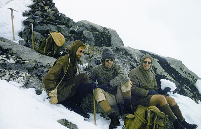
Mount Moroto stands at 3,082 meters above sea level in the Karamoja region in the north east of Uganda. Over the last few decades the region has witnessed war and conflict which has left its peaks predominantly unclimbed. Recently there has been a large-scale amnesty on guns and dip in the levels of violence. Steve Hynd from the Mountain Club of Uganda took this opportunity to see what the mountain has to offer.

P1120081The Foreign and Commonwealth Office (FCO) advise against all travel to Karamoja. They describe it is as:

largely lawless. There are frequent road ambushes and tribal clashes. Small arms are widespread and there are regular deaths or injury from gunshot wounds”

As it turned out, guns were the least of our problems…

We were travelling in a convoy along a dirt road which locals had told us was impassable during the rainy season. It was Saturday 30th March – the rainy season was due to starts on the April 1st.

On the road, there were a couple of hairy moments; wheels spinning on steeply banked rivers edges, deep mud that resulted in everyone getting out and walking but it was, in a 4X4, passable.

Two and half hours and 45km after leaving Moroto town we arrived at the small mountain village of Tapach.

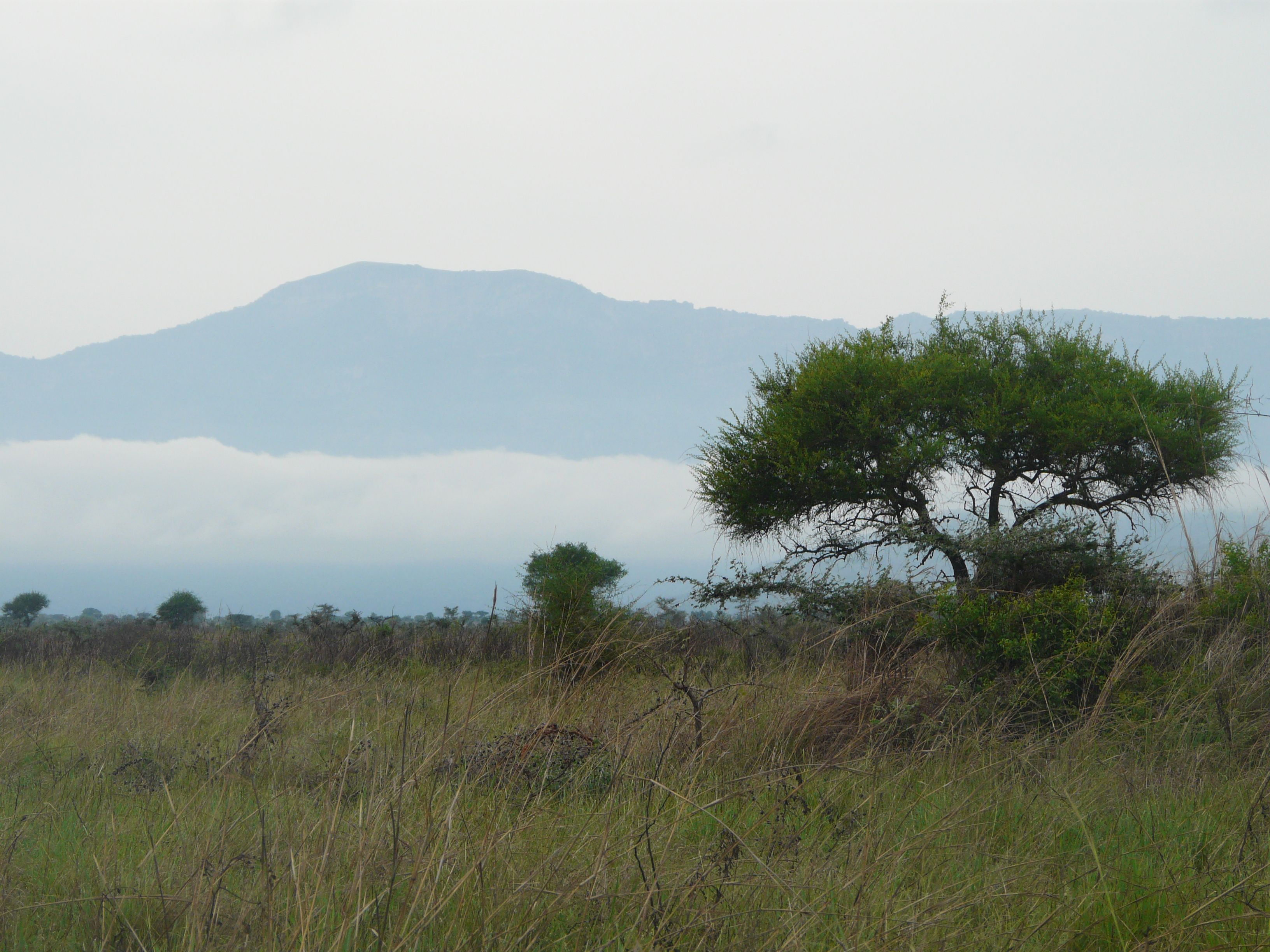
Tapach sits at the head of a valley tucked in underneath the imposing ridges that lead up to the peaks of Mt Moroto. The village boasts stunning views of the plains of Karamoja that stretch out away from mountain.

Living with some of the best views high on the side of the valley we found Friar Gerald – our only real contact in the village.

With a warm smile he greeted us while glancing at our mud covered cars before asking, “How was the road?” The only honest answer any of us could muster was, “passable”. He grinned a knowing grin and said, “It will be fine along as it doesn’t rain”.

P1120032Friar Gerald was accommodating and kind in helping us find local men to guide us up the mountain and ensured that at least one of them spoke English.

As we waited for the ‘guides’ to come back from the fields where they worked, I asked the Friar a little bit about the valley and the region. We talked about the lasting legacy that the conflict had on the village.

On the drive in we had passed a number of UPDF army camps and I asked if they ever came to the village and the Friar responded saying,

They keep themselves to themselves nowadays. I think that’s better for everyone”.

Clearly the memories of what happened in the region had not gone away. In 2007 Human Rights Watch described a government disarmament drive headed by the army in their report, “Get the Gun”. The report documented wide-spread use torture and a number of murders.

As the Friar said, perhaps it is best they keep themselves to themselves.

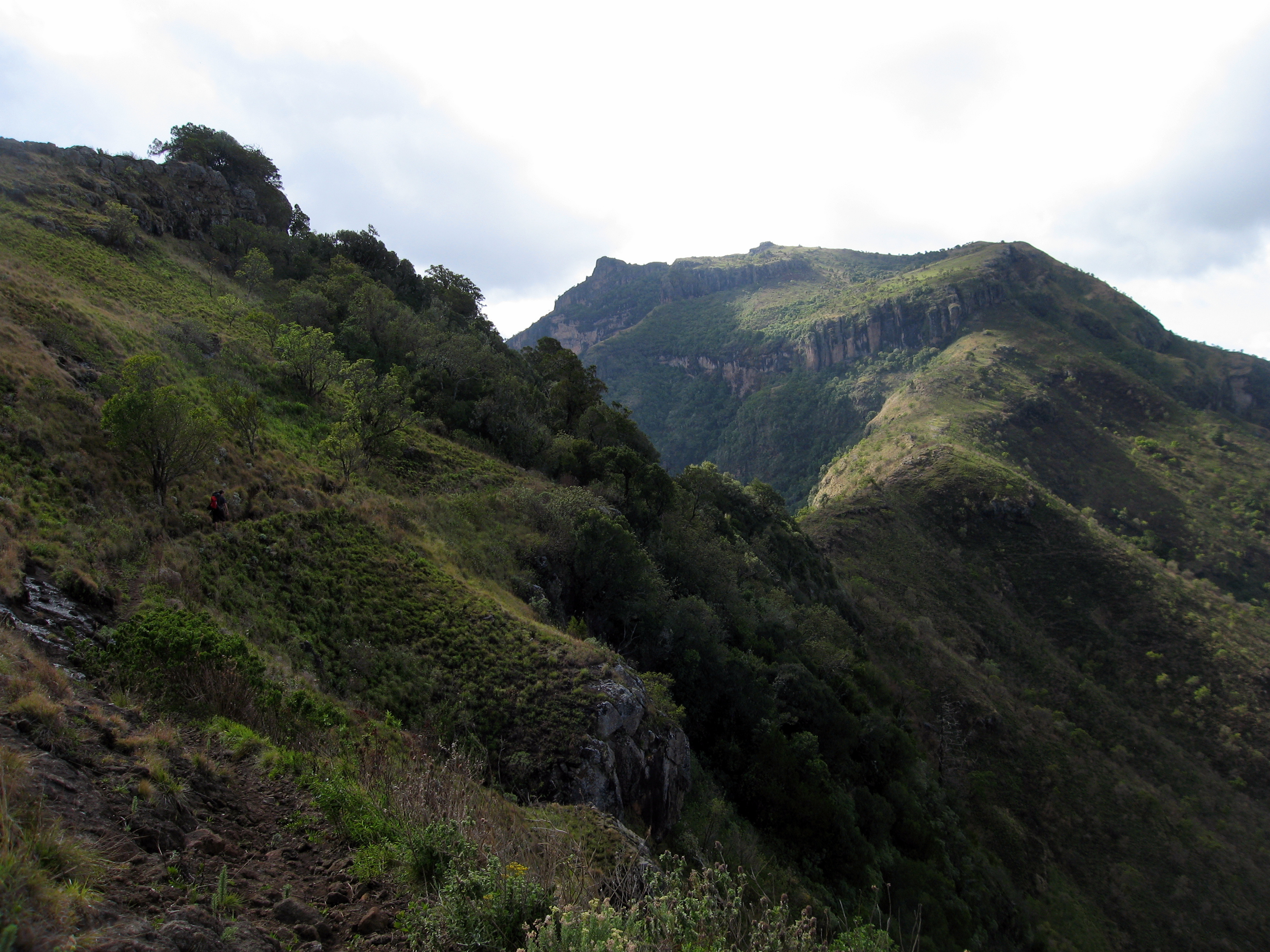
The guides soon arrived though and we started snaking our way up the hillside behind the monastery. The climb was tough going and this was extenuated by the 5 litres of water we were carrying as the guides were unsure as whether or not there was any water available on the mountain. The hot sun beat down on us as we huffed and puffed our way up the valley side.

The collecting storm clouds offered us only occasional shade.

Within an hour we were rewarded with panoramic views. In one direction there were the endless plains of Karamoja, on either side deep valleys with small hutted villages and in front of us the peaks of Mt Moroto.

Kyle IMG_3708By mid-afternoon we had climbed around 1,000 meters. High in the mountains the heavens opened in spectacular fashion. The intensity and consistency of the rain slowed our progress as we picked our way across rocky ridges and up steep muddy slopes.

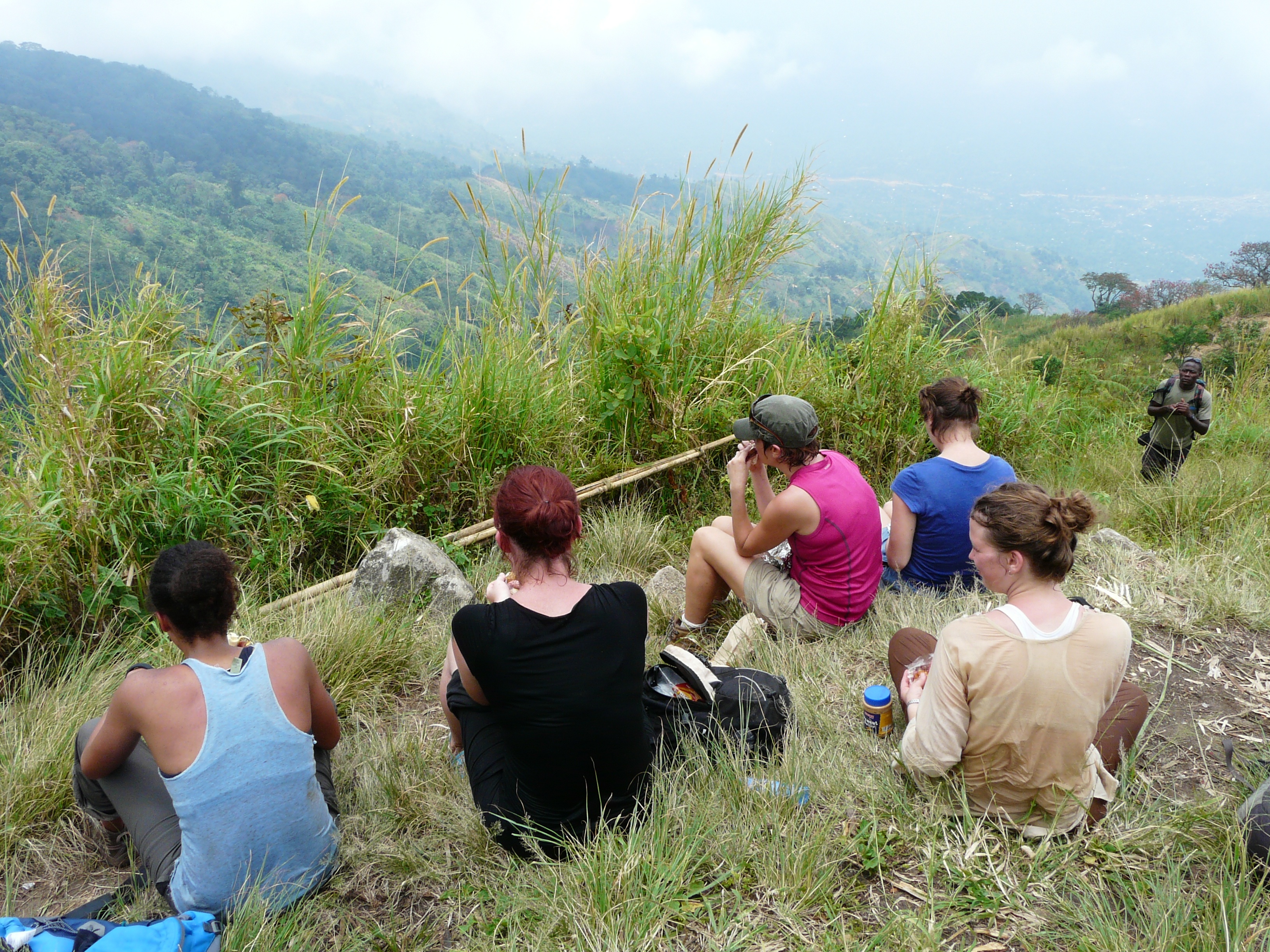
About an hour before dark we stopped high on a ridge to pitch camp.

The guides collected wood and lit a fire, the rest of us erected our tents and prepared food. On the equator the sun sets in a blink of an eye. For a brief moment though the storm clouds were silhouetted in front of departing sun before darkness descended on us.

P1120067That night we lay in our sleeping bags counting the seconds between thunder and lightning while the rain thundered on our tents. I am not sure if I have ever camped in more torrential rain.

Trying to not think about the rain and the state of the road back to Moroto I closed my eyes and let sleep take me.

The next morning we awoke before light and set off in a slow drizzle for the summit leaving our tents pitched on the ridge. The short walk took us through thick forest that clung to the ridge top. We scrambled up steep scrub land making the final assent with anything but elegance. Just under two hours after leaving camp we stood on the summit of Mt Moroto.

Starring into the thick mist I wondered how many other had stood where I was now stood. The answer, of course, is ‘not many’.

We made our way down, packing the camp on the way, slipping and sliding in the now thick mud. We arrived back at to the village at about 4pm with a sense of achievement but also dread about what lay ahead on the now sodden road back to Moroto.

Phoning ahead we found out that friends who were driving a Toyota Rav4 had left the village at 11am and were, at 4pm, still not back to Moroto.

I’ll admit now that I was worried – would we get back to the Moroto before dark? Would we get back at all?

Driving back was in itself an adventure. On a couple of occasions water came over the bonnet of the car, and on countless occasions the ground clearance proved in to be insufficient. But, just over two hours later we arrived back to our rendez vous in Moroto – 10 minutes after those in the Rav4 who left at 11 that morning.

I tried really hard not to be smug.

The other car load that left Tapach after us didn’t arrive back until 11 that night, they told me the next day that they had to cut out the seatbelts to use as a towrope.

The whole weekend was a mini adventure. We were not sure what we would find when we left Kampala for this remote region.  We had heard stories of guns, torture and of course incredible peaks. But what we found were warm welcoming locals who were slightly bemused as to why we wanted to climb Mt Moroto. The soldiers were courteous though and the locals delighted though that we were visiting.

Moroto district doesn’t yet have the infrastructure or the information to really capitalise on its mountaineering-tourism potential. But it does have mountains that are as beautiful as any in the national parks of Uganda.

With a good 4X4 and sense of adventure there is no reason why you cannot enjoy them as well.

If you fancy the trip – feel free to be in touch.

7 Comments

Filed under Outdoors, Travel, Uganda

Walking the Bwamba Pass with the Mountain Club of Uganda

A low level of laughter drifts in the air through the wood smoke as we crouch around the flickering campfire. Dotted around the fire are bits of bamboo that protrude from the ground. The sticks are sharpened to a point at one end and have chucks of beef skewered on them hanging over the open fire. The beef both absorbs the smell of the wood smoke and gives off a tantalising aroma.

Bottles of warm beer are passed around the circles while those who have learnt from experience sip of glasses of red wine poured from the box perched within arm’s reach. The sun has long since set on this small campsite in the northern tips of the Rwenzori mountains and the only light now comes from the flickering flames of the fire.

Sat around the fire are members of the Mountain Club of Uganda – a hodgepodge of people brought together by a passion for the mountains. The backdrop to this campfire is the highest mountain range in Africa – The Rwenzoris.

Sat next to me is Tom, a British ex-pat who spends his days working as a photographer for NGOs. He happily tears into the meat fresh from the fire and generously passes it around. I comment on how disappointing my oodles of noodles are in comparison and he laughs a knowing laugh as he takes a sip from his wine.

Opposite me I watch as Daivd, an American law graduate working in the Ugandan courts, chats happily with Manjit, a retired Indian British Doctor who is now volunteering in the International Hospital in Kampala. I catch their expressions in the fire light and their faces give away that they are evidently entering a conversation of substance, the sort of conversation that only occurs after a few beers when you are sat around a campfire.

People begin to pull jumpers on as the fire reduces to embers and the cool mountain air pushes the last of the day’s heat from the campsite. Most people head to their respective tents as the evening draws to a close leaving only the tough or the foolhardy passing around the Waragi. The knowledge of the next day’s walk acts as restraint for some but not all.

As I close up my tent door I listen for a few minutes to the conversation continuing between people who just 24 hours ago were strangers to each other. An ease of conversation created at least in part by the evenings consumption allows for jokes and jesting that would never have occurred elsewhere between such an eclectic group of people.

Despite the differences in age, nationality or anything else, we all there because of an unspoken timeless love affair between man and mountains.

I wake early the next morning before sunrise. The cool dew on the ground soaks into my flip flops as I stumble around half asleep making my preparations for the day’s walk. With a mixture of admiration and annoyance I meet the gentlemen who chose to stay the longest round the campfire and they look surprisingly sharp.

We collectively stumble into a convoy of cars and are driven for a couple of hours to the DRC side of the Rwenzoris from where we will trek over the Bwamba Pass back to the Fort Portal side of the mountain. Everyone sits in a dazed early morning silence as scenery slips pass the car window and we bump our way along increasingly pot holed roads.

We start our accent of nearly 1,400 meters with instant-grueling gradient. The group almost immediately splits into two as people begin to struggle in the now severe morning sun. Once again, with a mixture of admiration and annoyance, I note all of those who remained around the fire the longest striding away at the front. I sigh out loud and convince myself that I am at the back because I am being supportive to the others who were struggling with the heat and gradient.

Image
On the way up I walk the first couple of hours with Stephanie, an American originally from Florida who now lives in the northern Ugandan town of Gulu.  We meander together through agricultural land waving at the cries of the local children as we pass them. With good grace and admirable perseverance Stephanie walks up the unrelenting ascent listening to my equally unrelenting views on the Israel/Palestine conflict.

P1110965
To give everyone a break from the ascent and Stephanie a break from my incessant chattering we regroup and stop for lunch. The views are breathtaking as we look down over the steep slopes onto the plains which stretch out into the Congolese rainforest. From this vantage point you can begin to see why Stanley referred the Ituri Forest as “nothing but miles and miles of endless forest.”

With stomachs filled our small group set off in the heat of mid-day sun with nothing but altitude as relief from the heat. We move out of the agricultural lands and into deep thick rainforest. Walking in these conditions is a continuous contradiction as everything is sodden in the humidity and yet the heat forces a near continuous thirst. Many began to realise that their three litres of water might not be enough to get them over the pass.

Five hours, 1,400 meters ascents and some tired looking walkers later we reach the pass surrounded by thick bamboo forest. A second wind enters the group safe in the knowledge that it is all downhill from then on.

Image
It isn’t long though until the heavens open and hamper our progress.  Heavy balls of rain hit the red earthed paths we are following and reduce them to streams of slippery clay. As I pull on my full waterproofs I watch as Manjit smiles to the sky. With a twinkle in his eye he embraces the rain in his shirt sleeves and skips through the thickening mud.

While Manjit dances his way off the mountainside, others slip and slide their way down a series of precarious paths. Red mud marks the bottoms of those who lose their grip while red faces give away that for some the decent is as hard as the way up.

Walking with now almost unrelenting rain we finish our walk on the Ugandan side of the mountain range some seven hours after we set off.

Manjit stands topless as he wrings out his sodden t-shirt while the rest of us peel off our boots. Looking back I see the cloud curl round the hills and cover the path on which we had just descended. There is no hint at how far into the cloud the path goes or how far we had just come.

This small bit of knowledge remains for those who had just walked the Bwamba Pass.


*2 photos taken from Manjit’s blog – http://manjitsuchdev.wordpress.com/ *

3 Comments

Filed under Outdoors, Sport, Travel, Uganda