Tag Archives: MCU

70 years of mountaineering in Uganda

An edited version of this article was published in Saturday’s Daily Monitor – Uganda’s best selling independent newspaper. 

11615Summit Speke
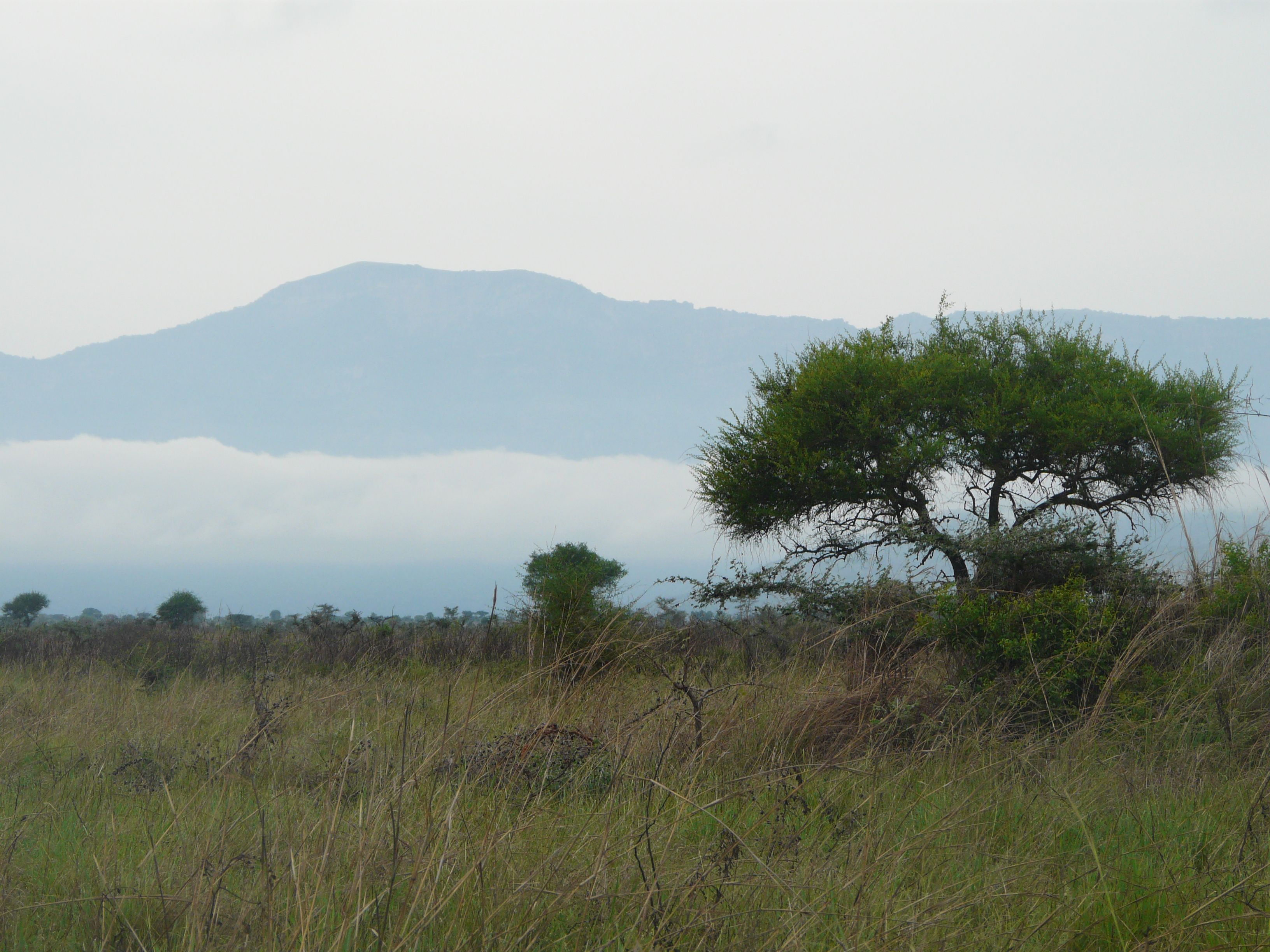
As the late afternoon mist draws down the valley the spectacular peaks of the Rwenzori mountain range are left tantalising exposed, reaching high up into the bright warm sky. The image of snow packed glaciers glistening on rocky mountain tops so close to the equator is one of the many wonders of mountaineering in Uganda and is cherished by those lucky enough to witness it.

Standing atop these majestic snow covered peaks is an experience that only a few have managed and perhaps, due to melting glaciers, only a few more will have the chance to see. Many perceive these peaks as too cold, dangerous or difficult to reach, but since its inception in 1945 the Mountain Club of Uganda (MCU) has been accessing and documenting the foothills and the peaks of this magnificent mountain range.

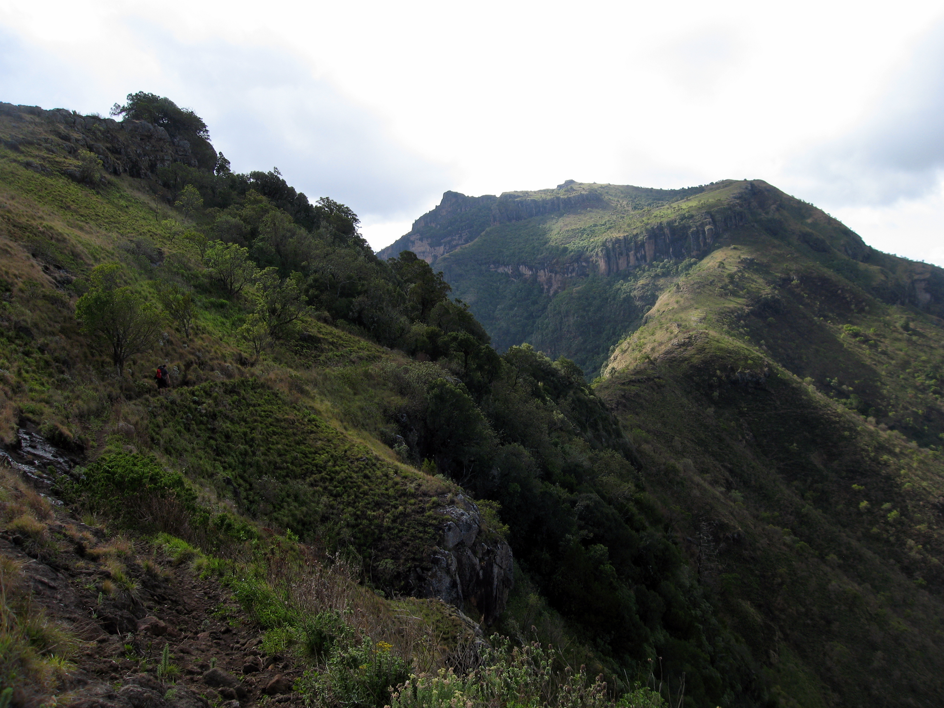
Soon to celebrate its 70th birthday, the MCU has undertaken renewed efforts to expand the Club and to fulfil its core mission: to encourage everyone in Uganda to enjoy, explore and celebrate the outstanding natural beauty that Uganda has been blessed with. This inevitably includes the mountaineering jewel – the range of the Rwenzori Mountains, but goes beyond this to cover all areas of the country.

Charlie Langan, the current President of MCU, talks keenly of the diversity of mountaineering in Uganda, saying, “Although the Rwenzoris provide an impressive challenge for anyone, Uganda has so much more to offer. From the hills of Agoro in the north, to the spectacular peaks of the Virungas in the south west, from the crater lakes of Fort Portal in the west to the peaks of Kadam and Napak in the East, Uganda has something for any level of fitness, enthusiasm and experience. At MCU we are here to help people get out and enjoy the outdoors in this incredible country.”

The MCU was first founded in the Geography Room in another of Uganda’s long standing institutions, Makerere University in Kampala.  The Club was originally founded as the Uganda section of the East African Mountain Club by Rene Bere along with students and lecturers but soon developed into the ‘Mountain Club of Uganda’ – a name that it still proudly bears today.

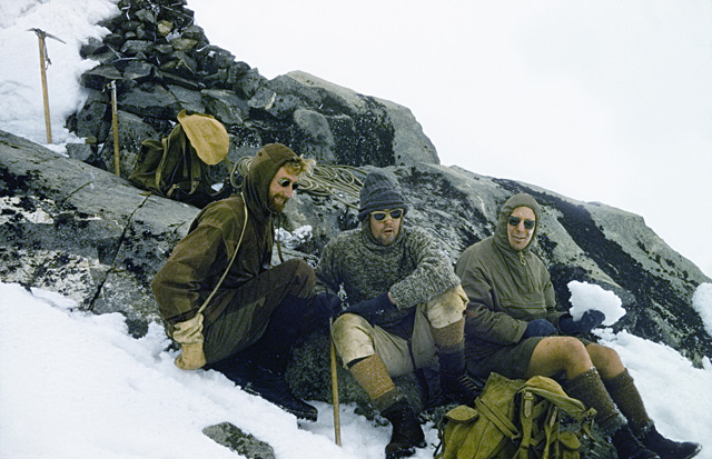
Indeed, it was in these early years that the MCU laid down the foundations for mountaineering in the country. Deo Lubega, the Club’s Patron who has been active in MCU for over 25 years, reminds newer Club members that it was the MCU who between 1949 and 1958 built a circuit of six huts on the Rwenzori Mountains as well as a hut on Mount Elgon and on Mount Muhavura. At the time the Club was dominated by expatriates but very early on decided to offer training for interested Bakonjo porters to offer formal porterage services on the Rwenzoris as an alternative source of income.

As such in 1960 Timothy Bazarrabusa became the first Ugandan to climb Margherita peak, 5,109m above sea level – the highest point in the Rwenzori range and Uganda. Bazarabusa went on to become the President of MCU and later its Patron and a key advocate for mountaineering in Uganda.

In 1972 MCU Presidents Henry Osmaston and David Pasteur published the “Guide to the Rwenzori’s”- a definitive guide to the range and its history and peoples. Along with Andrew Stuart and James Lang-Brown, these were some of the key figures in the history of mountaineering in Uganda who have documented and explored the mountain areas of Uganda.

Since that time the Club has held a commendable but somewhat discontinuous existence, due to political instability and restricted access to the mountains due to civil unrest. Today, as the MCU turns 70 it continues to build on its proud history and to open its doors to members old and new.

Langan, the current MCU President, commented, “In the last few years the Club has grown from a handful of people interested in mountaineering to a vibrant and diverse community of people eager to enjoy the outdoors. We have spread beyond simply walking and climbing and now regularly kayak on the river Nile, mountain bike through forests and villages and of course, meet up regularly to socialise with like minded friends.”

This ethos of encouraging others to enjoy the outdoors has also driven the Club to try and document the potential for climbing, walking and other activities in Uganda. Just as the Club proudly published a ‘Guide to Rock Climbing’ in 1963, so the Club is today editing the final draft of an updated guide to encourage others with a sense of adventure to leave the comfort of Kampala to head out and explore the extraordinary outdoor environment that Uganda has to offer.

More information:

Web: www.mcu.ug
Facebook: www.facebook.com/groups/mountainclubofuganda
Regular events: http://www.mcu.ug/?page_id=19

This slideshow requires JavaScript.

2 Comments

Filed under Outdoors, Travel, Uganda

Uganda’s Lawless Mountain: Mt Moroto

This article was written for Cotswold Outdoors Community Blog.

Mount Moroto stands at 3,082 meters above sea level in the Karamoja region in the north east of Uganda. Over the last few decades the region has witnessed war and conflict which has left its peaks predominantly unclimbed. Recently there has been a large-scale amnesty on guns and dip in the levels of violence. Steve Hynd from the Mountain Club of Uganda took this opportunity to see what the mountain has to offer.

P1120081The Foreign and Commonwealth Office (FCO) advise against all travel to Karamoja. They describe it is as:

largely lawless. There are frequent road ambushes and tribal clashes. Small arms are widespread and there are regular deaths or injury from gunshot wounds”

As it turned out, guns were the least of our problems…

We were travelling in a convoy along a dirt road which locals had told us was impassable during the rainy season. It was Saturday 30th March – the rainy season was due to starts on the April 1st.

On the road, there were a couple of hairy moments; wheels spinning on steeply banked rivers edges, deep mud that resulted in everyone getting out and walking but it was, in a 4X4, passable.

Two and half hours and 45km after leaving Moroto town we arrived at the small mountain village of Tapach.

Tapach sits at the head of a valley tucked in underneath the imposing ridges that lead up to the peaks of Mt Moroto. The village boasts stunning views of the plains of Karamoja that stretch out away from mountain.

Living with some of the best views high on the side of the valley we found Friar Gerald – our only real contact in the village.

With a warm smile he greeted us while glancing at our mud covered cars before asking, “How was the road?” The only honest answer any of us could muster was, “passable”. He grinned a knowing grin and said, “It will be fine along as it doesn’t rain”.

P1120032Friar Gerald was accommodating and kind in helping us find local men to guide us up the mountain and ensured that at least one of them spoke English.

As we waited for the ‘guides’ to come back from the fields where they worked, I asked the Friar a little bit about the valley and the region. We talked about the lasting legacy that the conflict had on the village.

On the drive in we had passed a number of UPDF army camps and I asked if they ever came to the village and the Friar responded saying,

They keep themselves to themselves nowadays. I think that’s better for everyone”.

Clearly the memories of what happened in the region had not gone away. In 2007 Human Rights Watch described a government disarmament drive headed by the army in their report, “Get the Gun”. The report documented wide-spread use torture and a number of murders.

As the Friar said, perhaps it is best they keep themselves to themselves.

The guides soon arrived though and we started snaking our way up the hillside behind the monastery. The climb was tough going and this was extenuated by the 5 litres of water we were carrying as the guides were unsure as whether or not there was any water available on the mountain. The hot sun beat down on us as we huffed and puffed our way up the valley side.

The collecting storm clouds offered us only occasional shade.

Within an hour we were rewarded with panoramic views. In one direction there were the endless plains of Karamoja, on either side deep valleys with small hutted villages and in front of us the peaks of Mt Moroto.

Kyle IMG_3708By mid-afternoon we had climbed around 1,000 meters. High in the mountains the heavens opened in spectacular fashion. The intensity and consistency of the rain slowed our progress as we picked our way across rocky ridges and up steep muddy slopes.

About an hour before dark we stopped high on a ridge to pitch camp.

The guides collected wood and lit a fire, the rest of us erected our tents and prepared food. On the equator the sun sets in a blink of an eye. For a brief moment though the storm clouds were silhouetted in front of departing sun before darkness descended on us.

P1120067That night we lay in our sleeping bags counting the seconds between thunder and lightning while the rain thundered on our tents. I am not sure if I have ever camped in more torrential rain.

Trying to not think about the rain and the state of the road back to Moroto I closed my eyes and let sleep take me.

The next morning we awoke before light and set off in a slow drizzle for the summit leaving our tents pitched on the ridge. The short walk took us through thick forest that clung to the ridge top. We scrambled up steep scrub land making the final assent with anything but elegance. Just under two hours after leaving camp we stood on the summit of Mt Moroto.

Starring into the thick mist I wondered how many other had stood where I was now stood. The answer, of course, is ‘not many’.

We made our way down, packing the camp on the way, slipping and sliding in the now thick mud. We arrived back at to the village at about 4pm with a sense of achievement but also dread about what lay ahead on the now sodden road back to Moroto.

Phoning ahead we found out that friends who were driving a Toyota Rav4 had left the village at 11am and were, at 4pm, still not back to Moroto.

I’ll admit now that I was worried – would we get back to the Moroto before dark? Would we get back at all?

Driving back was in itself an adventure. On a couple of occasions water came over the bonnet of the car, and on countless occasions the ground clearance proved in to be insufficient. But, just over two hours later we arrived back to our rendez vous in Moroto – 10 minutes after those in the Rav4 who left at 11 that morning.

I tried really hard not to be smug.

The other car load that left Tapach after us didn’t arrive back until 11 that night, they told me the next day that they had to cut out the seatbelts to use as a towrope.

The whole weekend was a mini adventure. We were not sure what we would find when we left Kampala for this remote region.  We had heard stories of guns, torture and of course incredible peaks. But what we found were warm welcoming locals who were slightly bemused as to why we wanted to climb Mt Moroto. The soldiers were courteous though and the locals delighted though that we were visiting.

Moroto district doesn’t yet have the infrastructure or the information to really capitalise on its mountaineering-tourism potential. But it does have mountains that are as beautiful as any in the national parks of Uganda.

With a good 4X4 and sense of adventure there is no reason why you cannot enjoy them as well.

If you fancy the trip – feel free to be in touch.

7 Comments

Filed under Outdoors, Travel, Uganda